
Living with Spring Flooding
Hannibal, Missouri is a mid-western town located on the western banks of the Mississippi River, just south of Quincy, Illinois, and about one hundred miles north of St Louis. It had already become an important river town by the year 1859, boasting over 1,000 steamboat landings annually.

Image of the historic Hannibal waterfront courtesy the Missouri Digital Library Collection
The average date for the start of navigation on the North Mississippi Region is March 22, depending on arrival of the spring thaw, and typically extends until Thanksgiving, about eight months, again, depending on the arrival of winter. Allowing for the additional days the river is closed to navigation for spring flooding or early winters, that’s an average of over 4 boat landings every day! That’s a lot of freight and passengers coming and going every day!

photo from Facebook page: Growing Up in Hannibal
Hannibal was becoming a center of trade and industry, largely due to its strategic location on the banks of the great Mississippi River between the high limestone bluffs to the north and south. In the years following the Civil War, in the era known as Reconstruction, Hannibal grew from a busy river port into a bustling and thriving center of commerce.

Hannibal was not only an important port along the Mississippi River, it also boasted a large shipyard, and a thriving lumber industry. Later, it became a central railway hub for the country’s expanding railroads.
Hannibal’s shipyard is where many Mississippi River steamboat hulls were built. Located at Soap Hollow, the valley north of town where the Hannibal waterworks pump station was later located, the hulls were towed to St. Louis for outfitting and installation of engines and superstructures.
Several well known boats were built at Soap Hollow, including the steam sidewheelers Marhta Jewett and the Robert Campbell, both built in 1850. Both were destroyed in a fire at St. Louis; the El Paso, which was built for Missouri River navigation in 1850, and the last boat constructed by Soap Hollow Boatworks was the Charles Belcher, a sidewheeler built in 1852, which too, was lost to fire in St. Louis. https://www.umsl.edu/mercantile/collections/pott-library-special-collections/assets/pdf/collections/Woold_Ridge_Steamboat_list.pdf.
Replica Steamboats
During my youth, however, the riverfront hustle bustle was long gone. The steamboat era had largely passed. Railroads were now dominate. There was only an occasional landing by a replica stern-wheel or paddle-wheel river boat scheduled for special events up or down the river. Frequently, they would provide an excursion from Hannibal’s riverfront for a few miles up or down river prior to departing for their main event.
Also, a locally owned excursion boat operated out of the riverfront area for many years, offering frequent hour-long river cruises and daily two-hour sunset buffet-dinner cruises, during the season. The three-story boat was cleverly outfitted with replica steamboat smokestacks, hand railings and paddle wheel housing to make it resemble a small steamboat. https://marktwainriverboat.com/

Most river traffic during my childhood, however, bypassed Hannibal in long lines of barges being pushed by river tugs to major ports further up or down the river. The exception to this was when long strings of barges were tied up near Turtle Island, waiting to load up the grain harvested from local fields. In this photo, a powerful river tug pushes barges against the current as it passes from view.
Hannibal Grain Terminal
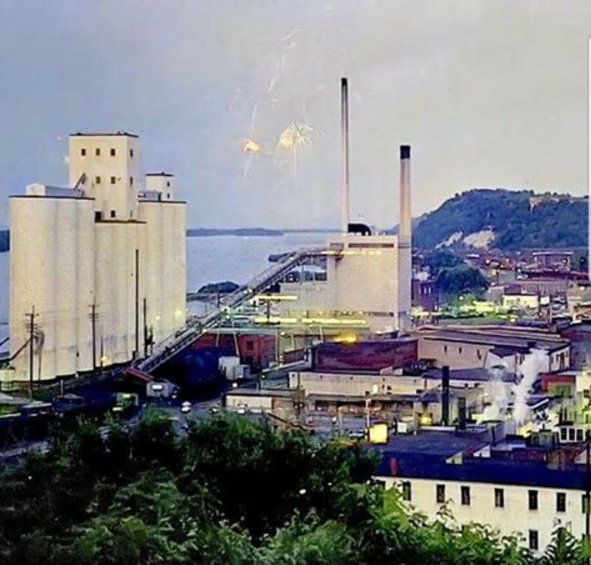
There were huge grain terminal buildings that dominated the riverfront and the skyline for many years. They loomed over the nearby Hannibal power plant and dominated the low lying area between the limestone bluffs that framed downtown. Cardiff Hill rose to the north, with its renowned lighthouse standing guard, and the legendary Lover’s Leap rising dramatically to the south.
In the fall, during the weeks of grain harvest, there would be a line of loaded farm trucks in the center lane of Broadway, sometimes a dozen blocks long, as they waited their turn to be unloaded at the elevator
In some years, when sufficient supplies of barges was not available, for whatever reason, drastic measures had to be taken to protect the incoming crop in temporary storage until sufficient barges could be obtained to ship the grain to market.

In 1955, with the grain elevators full, and barges late in arriving, wheat was again temporarily stored on a bed of overlapping tarpaulins laid in the center of Broadway at the riverfront, and covered with additional tarps to protect the crop from the weather. The parking spaces on either side became the traffic lanes for emergency vehicles only. Otherwise, the area was closed to motor vehicle traffic. Notice the block long pile of grain covered with tarps.
Spring Flooding
Hannibal floods were common when I was growing up. Our home was on the other side of Bear Creek, on the west edge of town, away from the river. But, when the Mississippi flooded, Bear Creek and two other creeks that fed into it, flooded, causing Lindell Avenue to be closed. The Mississippi flooded the CB&Q rail yards which were parallel to the river below Lover’s Leap, and Bear Creek and its tributaries would overflow into the Wabash yards at Lindell halting rail traffic.

In the spring of most years, my uncle, Joe Hoffman, had to use a rowboat or hitch a ride in one of the National Guard’s trucks, to reach the power plant to “keep the lights on.” In Hannibal the minor flood stage begins at 16 feet and the moderate flood level is 22 feet. At 22 feet it would flood everything for three blocks from the river’s edge. In 1993 the flood reached 29 feet!
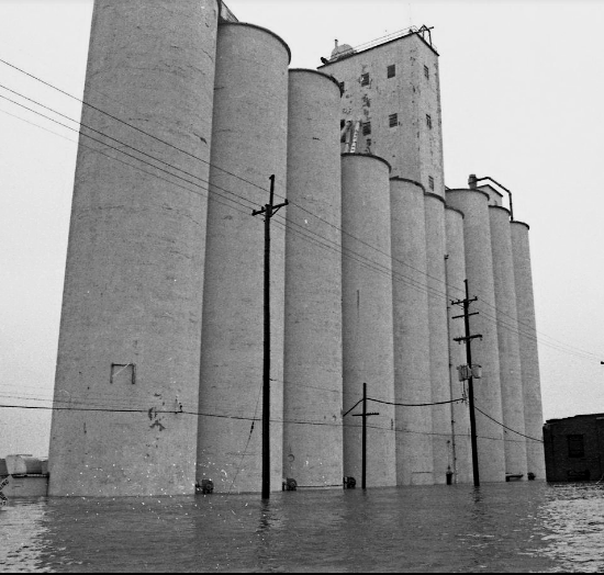
Hannibal Grain Terminal during the 1993 flood
The grain terminals were destroyed by the historic Great Flood of 1993, and had to be demolished as soon as the water receded. The dark building to their right was part of the electric power plant where my Uncle, Joe Hoffman, a WWII Navy veteran, worked. The power plant was also demolished soon after that flood.
The flood of 1993 occurred along the Mississippi and Missouri rivers and their tributaries, from April to October 1993. The flood was among the most costly and devastating to ever occur in the United States, with $15 billion in damages in around 30,000 square miles.


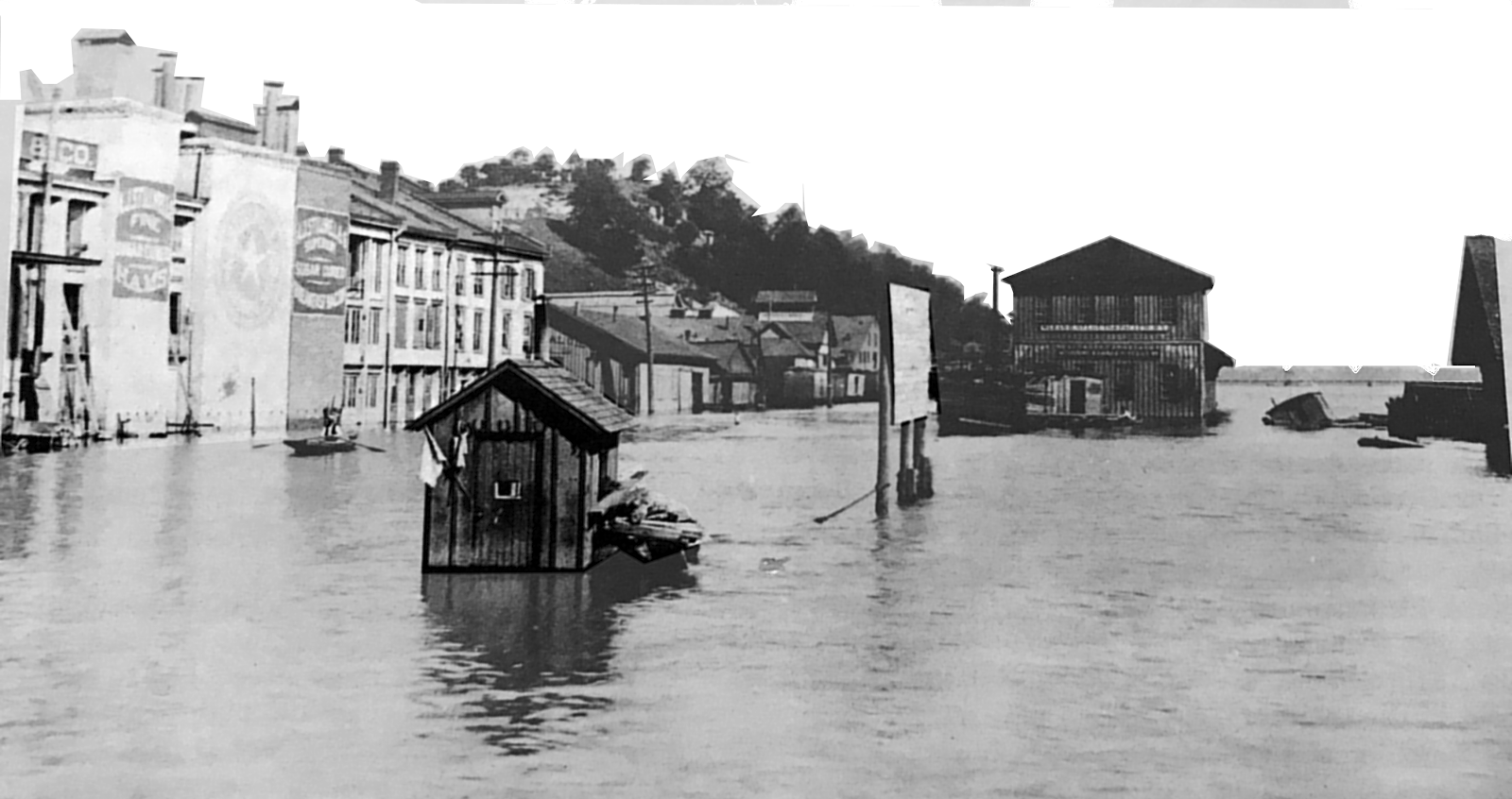
View of First and Bird Streets, along the waterfront in 1951. Note the commercial buildings along the street. Near the center of the photo, a railroad signalman’s shack displays warning flags on the front. Notice what appears to be a wooden caboose cupola floating near the right center of the photo.

Broadway at Main Street, during flood, 1951.

National Grocery Store, Collier and “Fourth Streets during flood

